Humphreys Peak, Flagstaff, AZ

Humphreys Peak, Flagstaff, AZ
Base meadow at Humphrey's Peak

Friday, December 30, 2011

Hike #10 - Quartz Trail - Phoenix, AZ


Monday, December 26, 2011 I hiked the Quartz Trail with my friend Cynthia Spaziani. We both took our dogs and dressed warm since the temp was in the low 40's when we started around 8:30 a.m.. Cynthia knew a lot of the people on the trail since she hikes this one on a regular basis. The 5 mile roundtrip trail is lined with palo verde trees, cactus and creosote bushes.

Hike #9 - Airport Loop Trail, Sedona, AZ


The final trail I hiked on my Sedona trip on November 6, 2011 was the Airport Loop Trail. This 3.4 mile hike was mostly flat and had incredible panoramic views of Sedona. The sky was overcast and it had snowed a couple days prior. The high was in the middle 40's but when you are hiking it feels warmer. The trail circles the Sedona Airport. Mark had taken beautiful sunset pictures from this area the night before. This is also a vortex spot.

Hike #8 - Boynton Canyon Trail, Sedona, AZ


After hiking Boynton Canyon Vista Trail, Mark and I hiked Boynton Canyon Trail. We did not go the full 2.5 miles but we probably went at least 1.5 miles before turning back to the parking lot. We passed the Enchantment Resort. It was an easy flat sandy trail with beautiful views of the red rocks in all directions. Some parts of the trail were in a forest of Juniper and other trees.

Hike #7 - Boynton Canyon Vista Trail, Sedona, AZ


Boynton Canyon Vista Trail was our second hike of the day, Saturday, November 5, 2011. As we started the trail we were greeted by a gentleman that gave me a heart shaped rock. I thanked him and put it in my pocket. As we hiked along the trail my friend Mark started noticing there were heart shaped rocks in all of the trees along the trail. I still have my rock from this hike. This is a short trail only a little over a half mile long. Boynton Canyon Spire is the end of the trail and there is also a vortex here.

Hike #6 - Cathedral Rock Sedona, AZ


Sedona is one of my favorite places and I had always wanted to hike there. My friend Mark Williams joined me November 4th-6th, for several hikes in Sedona. Cathedral Rock had a fresh layer of snow the morning we started our hike. The trail is 1.5 miles up and back with an elevation change of 600'. It was a bit of a challenge getting to the trail head due to the melting snow and high water we had to cross but we found a place to cross without getting our shoes too wet. The red rocks were slippery but thankfully people have carved steps into the rock which helped immensely. The view at the top was amazing and worth the climb. There is also a "vortex" at the top although we didn't really feel different or understand what that was about! Click on this link to see a video of this hike: http://www.sedonahikingtrails.com/videos/cathedral-rock/cathedral-rock-trail_video.htm

Hike #5 - 32nd St. Phoenix Mountain Park

This trail is only a 10 minute drive from my house. I have hiked this trail more than any other trail in Phoenix. The trail is 1.7 miles one way and sometimes I hike a different route coming back that adds another 1/2 mile or so. My friend Beth Peterson joined me in December 2011 along with my dog Riley. This is a great trail for dogs and children. There is a good chance of spotting coyotes, owls, quail depending on what time of day you are there.

Hike #4 - Havasupai near the Grand Canyon


This was my 4th time hiking Havasupai. My first time was in 1989 for my honeymoon. Havasupai is know for it's beautiful water falls. Our group of 8, booked early for the second week of October. We arrived Thursday night at Peach Spring which is approx. 45 min. from the trail head and stayed at a motel so we could start early the next morning. The mules carried our duffle bags of clothes and camping gear so that we could be more comfortable on the 10 mile hike. The first mile and a half consists of steep switchbacks. The remainder of the trail is mainly a winding wash that gradually turns into a canyon with gentle incline. We spent 2 nights at the camp ground. The weather was perfect and we were able to swim in the blue green pools. Both days we explored, relaxed and enjoyed our time away from our televisions, cell phones and computers. Instead we played card games, dice games and Backgammon. The hike out seemed to go fairly quickly but the last mile and a half up the switch backs is never easy. Thankfully we made the drive back to Seligman without running out of gas as there are not any services within 70 miles of the trail.

Hike #3 - Summit Trail at Piestewa Peak formerly Squaw Peak


This trail is closest to my house (5 min.!) and one of the trails I hike more frequently. I have used this trail to train for Rim to Rim at the Grand Canyon and also the Inca Trail. The distance is 1.2 miles to the summit with an elevation gain of 1200'. It is crowded with a lot of "regulars". One man I noticed going up a second time said he usually does it 6 times in one day! About 5 years ago, I was hiking in this area in the early morning just before the sun was up and I came within one step of a rattle snake! Thankfully it rattled it's tail and I stepped back until he passed. I have also seen coyotes, bats, owls, quail, shooting stars and beautiful cactus blooms in the Spring.

Wednesday, December 28, 2011

Hike #2 - The Inca Trail to Machu Pichu


In Septemeber, 2011, I joined Food for the Hungry (FH) for a mission trip aka "Trek for Hope" to Peru. This was my 8th mission trip to Peru with FH. We started with 14 people from all over the United States. The purpose of the mission trip was to speak about and model the love of Christ to families battling with domestic violence, restoring broken relationships with God, self, creation and man. The Inca Trail is high in the Andes mountains. We flew to Cusco, elevation 11,000' for 2 days prior to adjust to the elevation. Half of our group was not able to hike due to sickness or allergy related illnesses from the poor air quality in Lima. The elevation averaged between 9,000' and 12,000'. This was the most difficult part for me. We hiked for 3 1/2 days before getting to the Sun Gate of Machu Pichu at sunrise. Our hike was guided through GAP Adventures. They provided all of our equipment, porters to carry our gear and cook delicious meals at each camp site. The first day we hiked approx. 7 miles with not a lot of elevation changes. The second day was the hardest climbing to 12,700' to Dead Woman's Pass. The third day was challenging in that we hiked down 2,500 stone steps which was hard on my knees. The weather ranged from cold (40) in the shade to warm shedding your coat (65) in the sun so we were constantly changing out layers. The total length of the trail we hiked was approx. 25 miles.

Saturday, December 24, 2011

Hike #1 - Mount Humphreys, Flagstaff, AZ


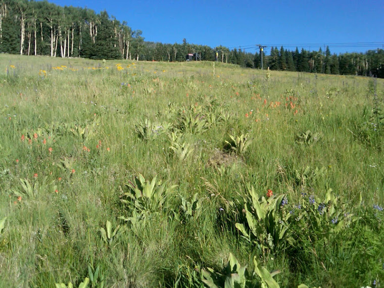
I did this hike in August of 2010 with my friend Mark Williams. We started close to noon on a Saturday and finished around 5 pm. We made it close to the summit and decided to turn around as we both were feeling light headed from the elevation. It was a beautiful day and the trail very lush with vegetation/forest.

The summit of Humphrey's Peak is the highest elevation in Arizona at 12,633 feet and one of the scenic rises among the San Francisco Peaks just north of Flagstaff, Arizona. Humphrey's, according to many avid hikers is the "best hike in Arizona" where those that reach the summit are rewarded with distant views of the Grand Canyon and Oak Creek Canyon as well as a 360 degree panoramic of the valley of beauty just below the Peak.

The trail is steep with a quick 3,333 foot elevation gain and becomes very rocky at it's higher reaches. The trail begins with wild flower covered meadows before reaching a dense forest of aspen, fir and spruce trees as it reaches the saddle connecting Humphrey's Peak with its sister peak, Agassiz.

Near the tree line, the thick forest is quickly left behind and replaced with bent and twisted bristlecone pines and plants that can only survive in tundra conditions. Those that have never hiked Humphrey's Trail can expect to reach three false summits before being rewarded with views from Arizona's highest point.