Humphreys Peak, Flagstaff, AZ

Humphreys Peak, Flagstaff, AZ
Base meadow at Humphrey's Peak

Sunday, March 25, 2012

Hike #26 - Wilson Mountain North, Sedona, AZ


"Wilson Mountain was named for Richaard Wilson, who was mauled and killed by a grizzly bear in 1885." (http://thehikehouse.com/?s=wilson+mountain)

This trail was recommended by my friend Paul Pastore who has hiked extensively in Sedona. This trail offers the best views I ever seen of Sedona. Paul and I hiked this trail Saturday morning, March 17, 2012, St. Patrick's Day.

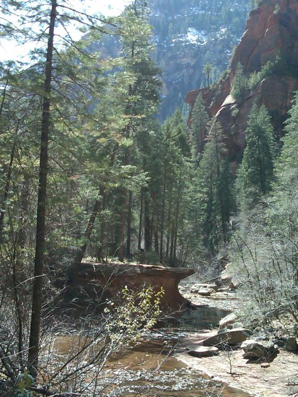
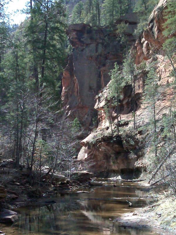
"Wilson Mountain is the highest mountain in the area, topping out at 7,122 feet. The trail climbs the cliffs from the 6,200-foot First Bench of Wilson Moutain up to the top of the mountain, with incredible overlooks on both the north rim and the south rim. The hike is a continuation of the First Bench trails (North Wilson Trail and Wilson Mountain to the First Bench). The mountaintop is covered with basaltic lava flows that date back 5 million years ago. From the summit are bird’s eye views of the entire area from 3,000 feet above the city of Sedona. The 360-views include the Verde Valley to the south, the San Francisco Peaks to the north, Oak Creek Canyon and the Mogollon Rim to the east, and the Red Rock Country to the west. (http://thehikehouse.com/?s=wilson+mountain)

Depending on which source you refer to this trail is anywhere from 3.7 to 5.3 miles one way. We took our time and enjoyed the views along the way. We saw no other people on the way up and approx. 10 people on the way down. This trail is considered difficult or strenuous due to the length and elevation gain of 2400'. See this short youtube video of this trail:

http://www.youtube.com/watch?v=r9Gkd0sH61I

Sedona, Az
Wilson Mountain Trail
www.efmer.eu/trails

Hike #25 - Munds Wagon Trail, Sedona, AZ


"This historic trail follows one of the first and most popular cattle trails out of the Sedona area. Upgrading of the trail began in 1896, but its completion as a wagon trail awaited the work of pioneer J.J. Thompson, funded by Coconino County, in 1902. It was known as the Munds Road and later as the Schnebly Hill Road." (Arizona Forest Service)
Paul and I hiked this trail the afternoon of March 16. It was another perfect weekend for hiking in Sedona. It is impossible to take a bad photo here! This trail runs parallel to Schnebly Hill road which is a popular road for the local tourist jeeps. I had taken the road before on ATV's and in the car but the trail offered even more scenic views. The trail is 4 miles one way and has 1,000' rise in elevation. The trail zig zags through several washes and after about 3 miles circles merry-go-round rock. There were other rock formations that looked like cow patties. Many parts of the trail are shaded by Arizona cypress trees. See this short youtube video of this trail:
http://www.youtube.com/watch?v=N4NZQdim2vE

Thursday, March 15, 2012

Hike #24 - Doe Mountain, Sedona, AZ


Doe Mountain is directly across from Bear Mountain and not far from the Enchantment Resort. Paul and I hiked this trail on March 11, in the afternoon. The weather was perfect and of course so was the scenery! This was our 4th hike for the weekend and one of the easiest. The trail is .7 miles long and has a 400' elevation gain. I got carried away taking pictures of the beautiful agave cactus and the cairns (trail markers). This is a popular trail and the large mesa at the top offers spectacular views.

Hike #23 - West Fork Oak Creek Trail, Sedona, AZ


I can see now why this is one of the most popular hiking trails in AZ and the most scenic! This is my favorite trail so far. The trail is 6 miles round trip with almost no elevation change. The trail extends an additional 11 miles unmarked into the Secret Mountain Wilderness. Tall pines, oak, aspen trees and even apple trees line the creek/trail. Since it was winter, a lot of the trees did not have leaves. It was fun crossing the creek multiple times on large stones and fallen trees. Since we hiked in March, there was still quite a bit of snow in the canyon where is was shadowed from the sun. I plan to do this trail again in the summer when the trees have leaves and the snow has melted. Paul and I hiked the morning of Sunday, March 11. We took our time as there were constant photo opportunites.

Hike #22 - Boynton Canyon Ruins


I had hiked the Boynton Canyon Trail back in November but this time decided to take an unmarked trail to see prehistoric cliff dwellings. This is a beautiful canyon with towering red buttes and crimson cliff walls, also a lush forest. "It begins relatively unimaginative but progressively crescendos from low growing manzanitas and scrub brush into a lovely hike through thick forests of ponderosa pine and scrub oak, alongside a shaded wash of worn red rock boulders."

Boynton Canyon is full of cliff dwellings built between A.D. 1125 and 1300 by the Verde Hohokam (aka Southern Sinagua). http://ruinsseldomseen.com/Boynton_Cyn.html

Prehistoric Indians made this area of Sedona home thousands of years ago. In fact there are still ancient Indian Ruins and burial sites hidden within the astounding beauty of this box canyon. Boynton Canyon is still sacred to the Yavapai Native Americans who consider Boynton as their place of origin. http://www.dreamsedona.com/boynton-canyon-hiking-trail.html

Hike #21 - Bear Mountain, Sedona, AZ


Bear Mountain in Sedona, AZ is a strenuous 4.8 (out and back) mile hike with an elevation gain of 1200'! Paul and I started hiking the morning of Saturday, March 10, 2012. The temperature was around 45 - 50 degrees, the sky mostly clear with a few wispy clouds. The sun kept us warm and within the first mile we were shedding our jackets. The trails in Sedona are red dirt from sandstone. The sandstone has a rough texture like sandpaper that makes it easy to grip with your shoes/hiking boots when climbing up or down. "The presence of iron is responsible for the rock color and the redness is actually rust."


"The Red Rocks of Sedona have a base that traces back to sediment in a sea or flood plain as well as some that formed from sand blown in from dry land or coastal area beaches. A point of origin determines the variation in sand color. It ranges from bright orange to shades of red and some tan. White or gray rocks are also visible. Once quite colorful, the effect of limestone or flushing water might have drained the color."

Read more: Facts About the Red Rocks of Sedona | eHow.com http://www.ehow.com/about_5313831_red-rocks-sedona.html#ixzz1pCo4c1g6

As we hiked we asked the other hikers what state they were from. By the end of the hike we had met people from 13 states and 2 countries, Canada & England.

Wednesday, March 14, 2012

Hike #20 - Lookout Mountain Circumference Trail, Phoenix, AZ


My dog Riley and I hiked this trail one morning the first week of March. There were very few people. The trail is 2.6 miles and little change in elevation. This trail is in the north of Phoenix, about 20 minutes from my house. Very peaceful with nice views.